Imagine you are building an automated pipeline to monitor global canopy loss using high-resolution, multi-spectral satellite imagery. The incoming dataset is massive—petabytes of raw images—and needs pixel-level classification (image segmentation) to detect areas of logging. To handle this workload efficiently, you must scale the processing across a multi-node high-performance cluster. Which of the following approaches is the most viable strategy for scaling and executing this image segmentation task?
Select an answer to reveal the explanation.
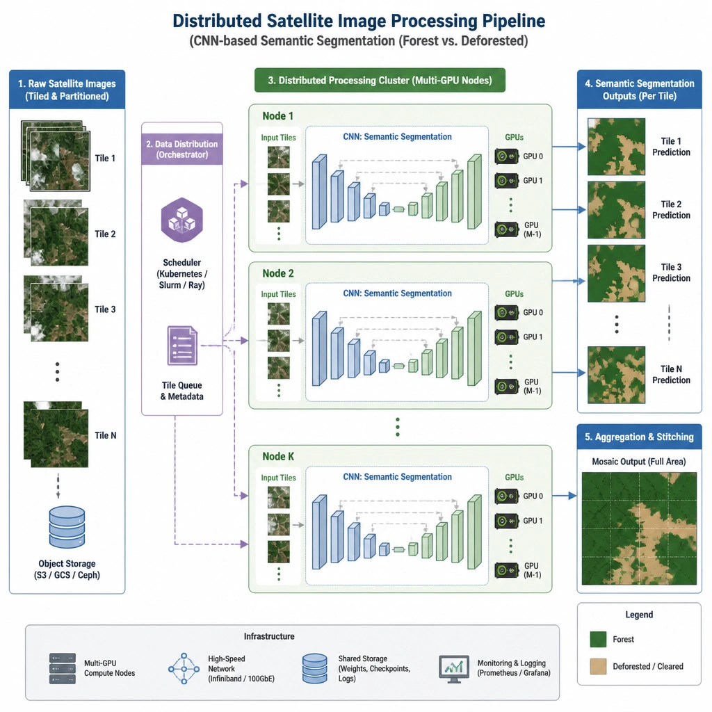
Short Explanation and Infographic
Check this out: if you try to process petabytes of high-res satellite imagery on CPUs, or try to do it manually, your project will be dead in the water before it even starts. We're talking about pixel-level classification here—that's semantic segmentation. To do this at scale, you need serious parallel processing power. That means GPUs, and because the dataset is too massive for a single machine, you have to distribute that workload across a cluster. A distributed, GPU-accelerated CNN is the only real-world way to handle this. It learns the complex spatial hierarchies in the images and cuts through the data like a hot knife through butter. Trust me, anything else will cause a major bottleneck. Got it? Sweet. Let's keep rolling.
Full explanation below image
Full Explanation
Analyzing massive geospatial datasets for tasks like deforestation detection requires both high-performance computing (HPC) infrastructure and specialized deep learning architectures. Pixel-level classification, also known as semantic segmentation, involves labeling every individual pixel in an image (e.g., distinguishing forest canopy from cleared land). Convolutional Neural Networks (CNNs), particularly architectures like U-Net or SegNet, are the industry standard for this because they excel at extracting spatial features and hierarchies. Because satellite datasets are incredibly large (often petabytes), a single GPU or node cannot process them in a reasonable timeframe due to memory and compute limitations. Distributing the training and inference workloads across a multi-node GPU cluster allows for data parallelism, where the dataset is partitioned and processed concurrently, and model state updates are synchronized.
Let's look at why the other options fail: Option A (SQL databases) is structurally inappropriate. Relational databases are designed for tabular, structured query operations and cannot handle the heavy tensor computations or unstructured binary data of high-resolution images efficiently. Option C (CPU-based multithreading with traditional edge detection) lacks the computational throughput of GPU tensor cores and the feature-learning capability of deep learning. CPUs excel at sequential processing, not the massive matrix operations required for image segmentation. Option D (crowdsourced manual annotation) is completely unscalable for ongoing, real-time global monitoring, as the sheer volume of satellite imagery generated daily would easily outpace human capacity.